
About the Area
The Willamette National Forest stretches for 110 miles along the western slopes of the Cascade Range in western Oregon.
The Forest’s northern extent is the upper reaches of the Santiam River as the melting snow flows off the glaciated slopes of Mount Jefferson; the river supplies drinking and irrigation water to canyon communities and to the City of Salem.
The Forest continues south where the McKenzie River flows west from the Cascade Peaks of Mt Washington, supplying the canyon communities and the cities of Eugene and Springfield with clear, clean, cool water. The southern extent of the Forest rises to Diamond Peak where the Middle and North Forks of the Willamette create canyons and broad valleys that support communities and strong fisheries.
The Forest is 1,675,407 acres in size. The varied landscape of high mountains, narrow canyons, cascading streams, and wooded slopes offer excellent opportunities for visitors and make the Forest valuable for many purposes.
The Willamette National Forest is easily accessed from the Willamette Valley cities of Salem, Albany, and Eugene. Four important highways-U.S. Route 20 and Oregon State Routes 22, 58, and 126-cross the Forest. Two National Scenic Byways, McKenzie Pass – Santiam Pass National Scenic Byway and the West Cascades National Scenic Byway take visitors on a tour of tall forests and sparkling water. Over 6,000 miles of road on the Forest offer a chance to get off the beaten path.
Climate and Topography
Elevations on the Forest range from about 1,500 feet above sea level to 10,495 feet at the snowcapped top of Mt. Jefferson, Oregon's second highest peak.
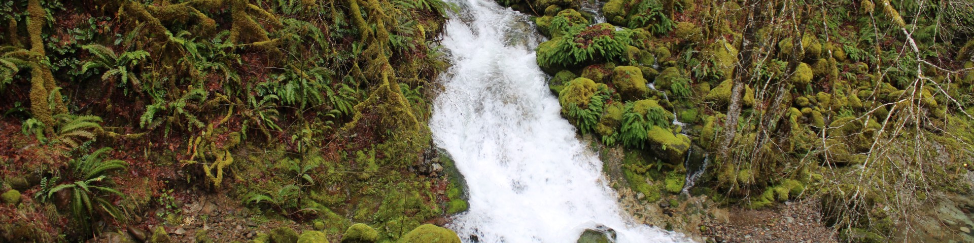
The Forest receives a large amount of precipitation each year, much of it as snow which blankets the higher peaks and ridges from October through April. The rain and melting snow drain into the headwaters of the McKenzie, Santiam, and Willamette Rivers, which flow from the Forest. There are over 1,500 miles of rivers and streams on the Forest and over 375 lakes, including many at elevations above 4,000 feet.
Natural History
Most of the Forest is covered with Douglas-fir, the State tree of Oregon and a valuable timber species in the United States. The Forest contains large stands of old-growth Douglas-fir, with diameters ranging from three to eight feet. Old growth stands can be seen along Fall Creek Trail and at other locations throughout the Forest.
At least 15 other conifer species are common on the Forest as well, including cedar, pine, hemlock, and several species of fir. Many parts of the Forest show the past effects of fire, insects, wind, and disease which are natural parts of forested ecosystems on the west side of the Cascades.
The Willamette is host to over 300 species of fish and wildlife, including the northern spotted owl, northern bald eagle, wolverine, and several other sensitive and threatened species. Steelhead, bass, chinook and kokanee salmon, and many kinds of trout are found in Forest lakes and streams which afford excellent fishing. Big game animals common on the Forest include Roosevelt elk, black bear, cougar, and black tailed and mule deer. Only the most careful observer will spot some of the larger species, as they tend to be wary and elusive.
The topography of the Forest shows the marked effects of glacial scouring and erosion. The are also several volcanic cones and lava flows. The McKenzie Pass (Hwy. 242) offers one most impressive views of volcanic activity in the continental United States.
History
The Willamette National Forest is named after the Willamette River, which begins on the Forest. (The "Wallamt" was the Indian name for a place on the river near present day Oregon City.) The Willamette National Forest was established originally as part of the Cascade Range Forest Reserve designated by President Grover Cleveland in 1893, and was administratively organized in its current form as a National Forest in 1933. It has been managed by the Forest Service within the U.S. Department of Agriculture since 1905.
Recreation
The Willamette National Forest offers a wide variety of recreation opportunities. Its central location makes it accessible to day-trippers and vacationers alike. Developed campgrounds, trails of all sorts, secluded spots along rivers and at vista points, roads that wind through beautiful forests, these are the features that draw visitors to the forest. Come, experience the Willamette.
The three major watersheds on the Forest are the Willamette (North and Middle Forks), McKenzie (South Fork and Blue River), and Santiam (North, Middle, South and Little North Forks and Breitenbush River). Hundreds of natural lakes wait to be explored. Numerous reservoirs exist on the Forest, all of which have campgrounds, picnic areas, campgrounds, and boat launches. Some have marinas and store facilities. Come out, enjoy yourself, and ‘follow the water’.
Wilderness
About one-fifth of the Forest, 380,805 acres, is Congressionally designated as wilderness. Seven major peaks of the Cascades -- Mt. Jefferson, Mt. Washington, Three Fingered Jack, Diamond Peak, North, Middle and South Sisters -- are within these wildernesses. Entry permits are required for all wildernesses for both day and overnight trips. Most are self-issuing at the trailhead, but some are limited entry and must be obtained in advance.
To preserve the natural processes of wilderness ecosystems, the use of motorcycles, mountain bikes, carts and other motorized and/or mechanized equipment is not permitted in wilderness, nor is gathering of special forest products such as tree seedlings, plant and minerals. When you visit the wilderness, please leave no trace. Pack out what you packed in.
Wild & Scenic Rivers
The forest has two rivers designated by Congress as Wild and Scenic Rivers, the McKenzie River and the North Fork of the Middle Fork of the Willamette River. These rivers are managed for protection of recreational opportunities as well as natural, scenic and historic qualities.
Scenic Routes
Scenic routes provide miles of spectacular scenery for Forest visitors. Unique attractions such as points of cultural, geological and historical interest can be found along the routes. Designated scenic routes are Clackamas-Breitenbush Road, McKenzie Pass-Santiam Pass National Scenic Byway, West Cascades National Scenic Byway (includes Aufderheide Memorial Drive), Over the River – Through the Woods Scenic Byway, Quartzville Backcounty Byway, and Diamond Drive.